Glossary of Flooding Terms E-F
THE EMERGENCY PROGRAM – The initial phase of a community’s participation in the National Flood Insurance Program (NFIP) if no flood hazard information is available or the community has a Flood Hazard Boundary Map (FHBM), but no Flood Insurance Rate Map (FIRM). A limited amount of flood insurance coverage at less than actuarial rates is available for all residents of the community.
EQUAL DEGREE OF ENCROACHMENT – A rule, used in determining permissible floodplain encroachments, that the floodplain on each side of a stream must be capable of conveying a proportionate share of the design flood flow.
FLASH FLOOD – A flood that reaches its peak flow in a short length of time (hours or minutes) after the storm or other event causing it. Often characterized by high velocity flows.
FLOOD OR FLOODING – Temporary inundation of normally dry land areas from the overflow of inland and/or tidal waters, and/or from the unusual and rapid accumulation or runoff of surface waters from any source. The rise in water may be caused by excessive rainfall, snowmelt, natural stream blockages, wind storms over a lake or ocean, tsunamis, extremely high tides, or any combination of such conditions.
FLOOD CONTROL – Keeping flood waters away from specific developments and/or populated areas by the construction of flood storage reservoirs, channel alterations, dikes and levees, bypass channels, or other engineering work.
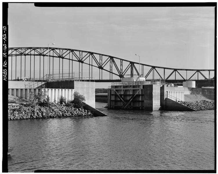
Human-made levee on the Mississippi River
Image credit: HABS
FLOOD CREST – The maximum stage or elevation reached or expected to be reached by the waters of a specific flood at a given location.
FLOOD DURATION – The length of time a stream is above flood stage or overflowing its banks.
FLOOD FIGHTING – Actions taken immediately before or during a flood to protect human life and to reduce flood damages such as evacuation, emergency sandbagging and diking, and provision of assistance to flood victims.
FLOOD FORECASTING – The process of predicting the occurrence, magnitude and duration of an imminent flood through meteorological and hydrological observations and analysis.
FLOOD FREQUENCY – A statistical expression of the average time period between floods equaling or exceeding a given magnitude. For example, a 100-year flood has a magnitude expected to be equaled or exceeded on the average of once every hundred years; such a flood has a one-percent chance of being equaled or exceeded in any given year. Often used interchangeably with “recurrence interval”.
FLOOD FRINGE – The portion of the floodplain outside of the floodway or coastal high hazard area but still subject to flooding. Sometimes referred to as “floodway fringe”. Also used to refer to areas subject to flooding by water with little or no velocity.
FLOOD HAZARD BOUNDARY MAP – An official map of a community issued by the Federal Insurance Administration on which the boundaries of the floodplain (i. e. ,subject to the 100-year flood), mudslide and/or flood-related erosion areas having special hazards have been drawn.
FLOOD HAZARD BOUNDARY MAPPING PROGRAM – Federal Emergency Management Agency (FEMA) program that identifies flood hazards, assesses flood risks and partners with states and communities to provide accurate flood hazard and risk data to guide them to mitigation actions.
FLOOD HYDROGRAPH – A graph showing, for a given point on a stream, the discharge, height or other characteristic of a flood with respect to time.
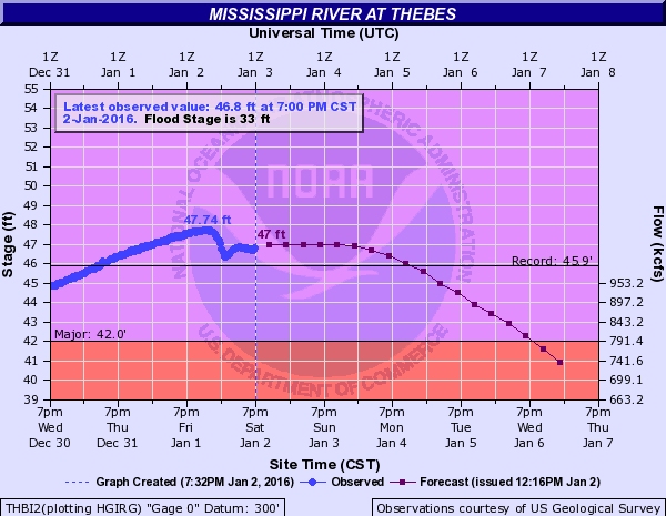
Image Credit: NOAA
FLOOD INSURANCE – Insurance on structures and/or their contents for their restoration or replacement if damaged by floodwater.
FLOOD INSURANCE RATE MAP – An official map of a community on which the Federal Insurance Administration has delineated the area in which the purchase of flood insurance is required under the Flood Insurance Regular Program.
FLOOD INSURANCE REGULAR PROGRAM – The phase of the National Flood Insurance Program under which actuarial rates have been determined.
FLOOD PROFILE – A graph or plot of the water surface elevation against distance along a channel drawn for a specific flood or level of flooding.
FLOOD OF RECORD – The greatest flood recorded for a location. Usually referred to as the “maximum flood of record”. The term is also sometimes used to mean any flood for which there is a measurement of height or other systematic or reliable record useful for technical analysis.
FLOODPLAIN – The low lands adjoining the channel of a river, stream or watercourse, or ocean, lake, or other body of standing water, which have been or may be inundated by flood water. The channel of a stream or watercourse is a part of the floodplain.
FLOODPLAIN DELINEATION – The process of showing in a graphical form, usually on a map or photo mosaic, areas which have been inundated by a specific flood or which can be expected to be inundated by a predicted flood of specific magnitude.
FLOODPLAIN MANAGEMENT – The operation of a program intended to lessen the damaging effects of floods, maintain and enhance natural values, and make effective use of related water and land resources within the floodplain. It is an attempt to balance values obtainable from use of floodplains with potential losses arising from such use. Floodplain management stresses consideration of the full range of measures potentially useful in achieving its objectives.
FLOODPLAIN REGULATIONS – A general term for the full range of codes, ordinances, and other regulations relating to the use of land and construction within stream channels and floodplain areas. The term encompasses zoning ordinances, subdivision regulations, building and housing codes, encroachment line statutes, open-space regulations, and other similar methods of control affecting the use and development of these areas.
FLOOD PROBABILITY – A statistical expression of the chance (usually as a percentage) that a flood of given magnitude has of being equaled or exceeded in any one year (see flood frequency).
FLOODPROOFING – A combination of structural changes and adjustments to existing structures and facilities, their contents and/or their sites purpose of reducing or eliminating flood damages by protecting against structural failure, keeping water out, or reducing the effect of water entry.
FLOOD WARNING – The issuance and dissemination of information about an imminent or current flood.
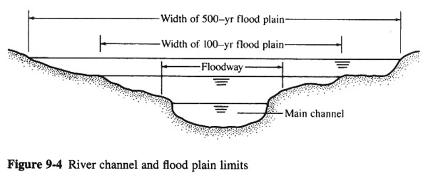
Image credit: San Diego State University
FLOODWAY – The channel of a watercourse and those portions of the adjoining floodplain required to provide for the passage of the selected flood (normally the 100-year flood) with an insignificant increase in the flood levels above that of natural conditions. As used in the National Flood Insurance Program, floodways must be large enough to pass the 100-year flood without causing an increase in elevation of more than a specified amount (one foot in most areas).