Glossary of Flooding Terms G-Z
GROUNDWATER RECHARGE – The infiltration of water into the earth. It may increase the total amount of water stored underground or only replenish supplies depleted through pumping or natural discharge.
HYDRODYNAMIC LOADS – Forces imposed on structures by floodwaters due to the impact of moving water on the upstream side of the structure, drag along its sides, and eddies or negative pressures on its downstream side.
HYDROSTATIC LOADS – Forces imposed on a flooded structure due to the weight of the water.
LEVEL (DEGREE) OF PROTECTION – The greatest flood level against which a protective measure is designed to be fully effective; often expressed as a recurrence interval (e.g. , 100-year level of protection) or as an exceedance frequency (e.g., one-percent chance of exceedance).
NATURAL VALUES OF FLOODPLAINS – The desirable qualities of or functions served by floodplains including but not limited to water resources values (e.g., moderation of floods, water quality maintenance and groundwater recharge), living resources values (e.g., fish, wildlife and plant resources and habitat), cultural resources values (e.g., open space, natural beauty, scientific study, outdoor education, and recreation), and cultivated resource values (e.g., agriculture, aquaculture and forestry). Also referred to as Ecosystem Services.
NONSTRUCTURAL MEASURES – All floodplain management measures excepting structural flood control works. Examples of nonstructural measures are flood warning/preparedness systems, relocation, floodproofing, regulation, land acquisition, and public investment policy.
ONE-HUNDRED YEAR FLOOD – A flood having a one-percent chance of occurring in any given year and which, over a very long period of time, can be expected to be equaled or exceeded on the average of once every hundred years. Alternate definitions that question the terms of this established definition.
OVERLAND RUNOFF – That portion of precipitation which is not intercepted by vegetation, absorbed by the land surface or evaporated, and thus flows overland into a depression, stream, lake or ocean (runoff called “immediate subsurface runoff” also takes place in the upper layers of the soil).
PROBABLE MAXIMUM FLOOD – The most severe flood that may be expected from a combination of the most critical meteorological and hydrological conditions that are reasonably possible in the drainage basin. It is used in designing high-risk flood protection works and siting of structures and facilities that must be subject to almost no risk of flooding. The probable maximum flood is usually much larger than the 100-year flood.
RECURRENCE INTERVAL – A statistical expression of the average time between floods equaling or exceeding a given magnitude (see flood frequency).
REGULATORY FLOODPLAIN – That portion of the floodplain subject to floodplain regulations (usually the floodplain inundated by the one-percent chance flood).
REGULATORY FLOODWAY – The channel and that portion of the adjacent land area that is required through regulations to pass flood flows without increasing the water surface elevation more than a designated height.
RESERVOIR – A natural or artificially created pond, lake or other space used for storage, regulation or control of water. May be either permanent or temporary.
STANDARD PROJECT FLOOD – A term used by the U.S. Army Corps of Engineers to designate a flood that may be expected from the most severe combination of meteorological and hydrological conditions that is considered reasonably characteristic of the geographical area in which the drainage basin is located, excluding extremely rare combinations. The peak flow for a standard project flood is generally 40 to 60 percent of the probable maximum flood for the same location.
STREAM – A body of water flowing in a natural surface channel. Flow may be continuous or only during wet periods. Streams which flow only during wet periods are termed “intermittent streams”.
STRUCTURAL MEASURES – Flood control works such as dams and reservoirs, levees and floodwalls, channel alterations, seawalls, and diversion channels which are designed to keep water away from specific developments and/or populated areas or to reduce flooding in such areas.
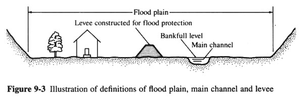
Image credit: San Diego State University
SUBSIDENCE – Sinking of the land surface, usually due to withdrawals of underground water, oil, or coal.
WATERCOURSE – A natural or artificial channel in which a flow of water occurs either continuously or intermittently.
WATER SURFACE ELEVATION – The heights, usually in relation to mean sea level, reached by flows of various magnitudes and frequencies at pertinent points in the floodplain.
WETLANDS – Areas that are inundated or saturated at a frequency and for a duration sufficient to support a prevalence of vegetative or aquatic life requiring saturated or seasonally saturated soil conditions for growth and reproduction.