The Mississippi River & Tributaries project (MR&T) was a result of the devastating 1927 flood on the Mississippi River. Congress directed the U.S. Army Corps of Engineers (Corps) to design this system for the lower portion of the Mississippi River, essentially from Cairo, IL to New Orleans, LA, to pass what was estimated to be the “flood of record”. It relies upon large levees to contain the river flow and several floodways and backwater areas to provide additional storage capacity when necessary (See Figure 1). The system does not use natural floodplain storage capacity but retains the early 1900’s Corps’ philosophy that humans can control floods by pushing the water through the system as fast as possible. When the water cannot be contained between the levees, the floodways and backwater areas are utilized.
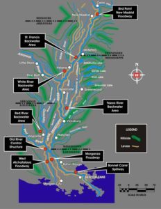 |
The system has been operated several times, not always using all components. The 1937 flood was the first real test and the 2011 flood the most recent with both of these floods requiring the use of the entire system including the New Madrid Floodway.
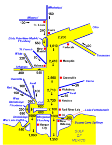
It is important to note that the majority of the volume of the estimated floodwaters for the MR&T originates from the Ohio River system (2.250 mcfs), not the Upper Mississippi River (.240 mcfs). This is shown in Figure 2. Flow from the Ohio River is nearly 10 times that of the UMR. The total flows increase below the UMR and Ohio River confluence because of the contribution of floodwaters from more southerly tributaries.
 |