The Missouri Coalition for the Environment (MCE) has been working to preserve the natural value of Missouri’s floodplains for over 40 years. Lawsuits filed by MCE resulted in a consent agreement forcing the Corps of Engineers to regulate navigable waters up primary tributaries to the ordinary high water mark. MCE was critical in the effort to prevent development of a sports multiplex in the Missouri River floodplain that would have moved the professional football and baseball stadiums out of downtown St. Louis. MCE remains involved with floodplain issues on several levels and in various locations.
Floodplains, especially when they contain wetlands, provide free services of great value to us. Besides being capable of storing large volumes of flood water, floodplains purify water, help recharge aquifers, supplement soil fertility, provide food and fiber, maintain biodiversity and offer recreational opportunities.
Some of our best soil for farming is found in floodplains created through periodic river flooding that leaves sediment and nutrients essential for soil fertility. The high quality soil of floodplains attracted farmers who also benefited from the nearby river transportation system. Levees were eventually built around the land to protect it from the flooding that had created the fertile soil. Concurrently, drainage systems were constructed within the farmed floodplain that drain wetlands and lowered the water table. By the early 1900s large tracts of farmland were separated from the floodplain by levees.
Levees
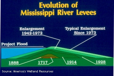
Concurrent with the river management activities of the Corps of Engineers, there was immense construction going on within the floodplains of the rivers building levees to protect urban areas and farm fields from the periodic flooding of the river. Initially the levees built around the time of the Civil War were small but as more of the floodplain became occupied and levees were overtopped or breached, the structures became larger. By the late 1800s, the Corps of Engineers was in the levee construction business as well, initially repairing damaged levees, but by 1917, Congress directed the Corps of Engineers to add flood control to its mission list (Source: USACE, 2006, Upper Mississippi River Comprehensive Plan – Main Report, Draft).
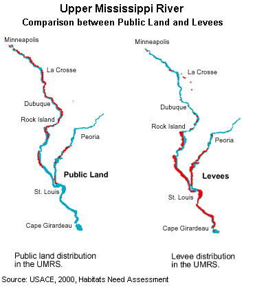
 More and higher levees built to protect farmland, typically organized into levee districts, have disconnected the vast majority of the river’s floodplain from the river in both the Missouri and Mississippi Rivers. The distribution of levees coincides nearly directly with the distribution of private land holdings along the rivers; the more privately held land, the more levees separating the floodplain from the river and this distribution is very evident on the Upper Mississippi River with levees increasing dramatically from north (nearly nonexistent above the Quad Cities) to south (over 80% of the floodplain leveed).
 Hundreds of thousands of acres of the floodplain have been either disconnected or altered along both the Missouri River and the Upper Mississippi River by thousands of miles of levees. Although farmers have benefited from the protection of levees, due to the immense area now leveed, there has been a significant altering of the rivers’ capability of absorbing flood waters and the raising of the rivers flood stages. This has resulted in increased flooding in areas not protected by levees. Flooding that originally covered the land with just a few inches to maybe a couple feet now receive several feet of floodwater. Studies have shown that the 1993 flood would have been 10 feet lower absent the levees constructed since 1927.
Midwest Flood of 1993
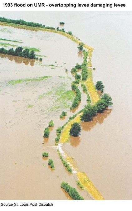
The Midwest Flood of 1993 affected both the lower Missouri River and the Upper Mississippi River along with several of their tributaries. The flood caused about $15 billions of dollars in damages and was too high for most farm levees. Instead of a gradual flooding of these areas, the flood waters entered the farmland through breaks in levees causing deep scours in the soil and depositing many feet of sediments.
 The 1993 flood generated several in-depth studies of flooding in the region and included recommendations to help move the region towards a different development path that would reduce the impacts of floods by living within the constraints and limits of the river. Some of these recommendations included:
- Buy-outs of flooded property including whole communities
- Raising buildings and infrastructure above a specific flood stage
- Establish a system-wide management of the river basin that would include land-use, pollution control, effects of hydrological changes within the river caused by levees, navigation structures and loss of wetlands
- Land acquisition as an option for natural areas restoration
- Modify, set back or remove levees to allow additional flood storage capacity and minimize flood damage
- Purchase flood easements to compensate land owners
- Promote the substitution of row crops with perennial flood tolerant crops and plants
- Require landowners to cost share levee construction and maintenance cost
Although a small number of actions followed these recommendations including moving the town of Valmeyer, IL to a new location out of the floodplain, typically the recommendations were ignored and we have raised levee heights and continued to develop in the floodplains, even within areas that were under more than 10 feet of floodwaters in 1993.
