Members of the general public as well as conservation and environmental groups turned out to share their perspectives about flood risk management, extreme precipitation, floodplain restoration, and making room for the river during a meeting hosted by the Upper Mississippi River Basin Association (UMRBA) and the U.S. Army Corps of Engineers in Hannibal on July 13. This was the first of six Saturday sessions that will take place along the Upper Mississippi River this summer. Join us at one of the remaining four gatherings:
- July 27 in Dubuque, Iowa at the Grand River Center
- August 3 in Winona, Minnesota at the Minnesota State College SE
- August 24 in Godfrey, Illinois at the Lewis and Clark Community College
- September 7 in Cape Girardeau, Missouri at the Southeast Missouri State University
The theme of these Saturday sessions is “What can we do to more effectively address the issues of flooding, navigation channel maintenance, sediment management, and long term drought?” The sessions are open to the public, and the “open space” meeting format is meant to encourage meeting participants to pick the topics that they want to talk about and drive the discussions.
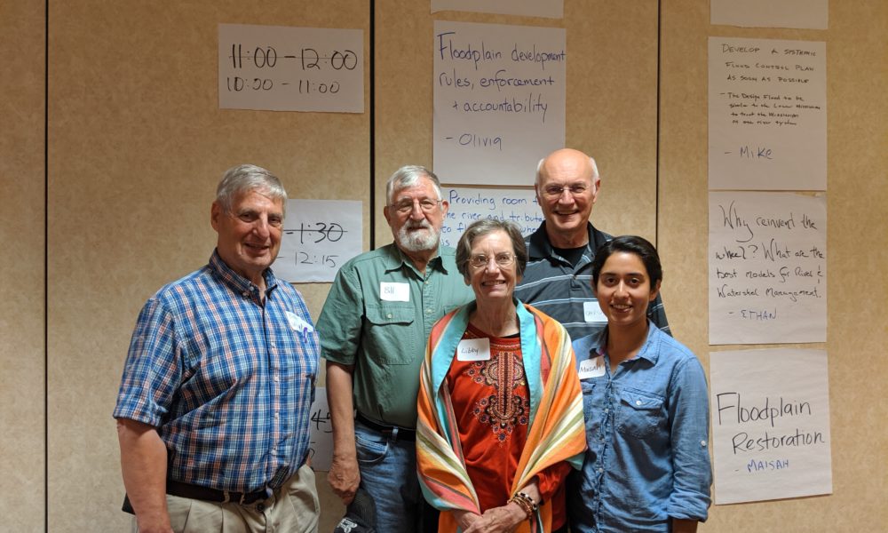
The topics raised and the discussions that took place at the Hannibal meeting on July 13 included:
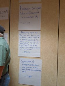
- Providing Room for the River
- Floodplain Development Rules, Enforcement, and Accountability
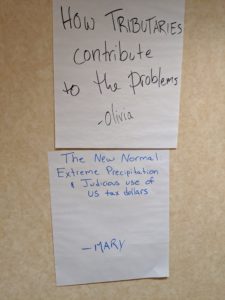
- How Tributaries Contribute to the Problems
- The New Normal: Extreme Precipitation and Judicious Use of U.S. Tax Dollars
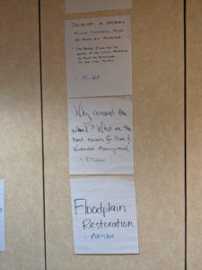
- Why Reinvent the Wheel? What are the best models for river and watershed management?
- Floodplain Restoration
- Expectation of Floodplain Landowners — What solutions do landowners want and ideas for implementation?
Photos: Participants were asked to write down their discussion topics on large sticky notes and facilitate group discussions.
Flood-Risk Management
Many of these conversations elevated the need to take a “flood risk management” approach to solving problems like flooding along the river. This type of approach focuses on the people and the risk factors involved with living in flood-prone areas, rather than attempting to control the river with more built infrastructure. “Flood Control,” in the parlance of the Army Corps, is limited to creating ever-more and ever-larger “grey infrastructure” on the river such as levees, floodwalls, and pumps. While this infrastructure can protect some communities and property in the short-term, it does not address the long-term causes of flooding, and it puts under-resourced communities (that cannot afford to build such infrastructure) at increased risk.
Basin-Wide Approach
Taking a basin-wide approach to Upper Mississippi River management is another point that was raised at the Hannibal meeting. In hydrological terms, the “mainstem” of a river refers to the primary downstream segment of the river. Water enters the Mississippi River’s mainstem through the river’s drainage basin — or the land area through which all of the tributaries to the Mississippi River flow. Much of the water in the Mississippi River comes from its tributaries, so good management of flood risk, sediment, or water quality on the mainstem of the river must take into account the impact of its tributaries.
Making Room for the River
Decades of intense management along the Mississippi River has stripped it of its natural recourse for high water events — floodplains and wetlands. The dramatic increase in built infrastructure (levees and dams) along the river has also facilitated rapid, widespread development in floodplains as well as increased crop and pasture land. These developments have not only increased flood risk by putting people and property in harm’s way, but also destroyed precious floodplain and wetland habitats. We also know that the creation of levees have made flooding impacts worse. We can mitigate these flood risks by making room for the river through levee set-backs, community-supported floodplain buy-outs, and floodplain easements.
Floodplain Restoration and Nature-Based Solutions
Healthy floodplains benefit communities by absorbing floodwaters that would otherwise rush downstream, threatening people and property. It has been estimated that restoring the 100-year flood zone of the five-state Upper Mississippi River Basin could store 39 million acre-feet of floodwaters — the same volume that caused the Great Flood of 1993 — and save over $16 billion in flood damage costs. Climate change (increased precipitation in the basin and increased extreme weather events) is also contributing to the severity and intensity of floods, and restoring floodplain ecosystems to their natural, dynamic states will increase climate resilience in the Mississippi River basin.
What issues are important to you? What are your ideas for how to address flooding along the Mississippi River?
Make your voice heard at one of the upcoming public meetings this summer:
- July 27 in Dubuque, Iowa at the Grand River Center
- August 3 in Winona, Minnesota at the Minnesota State College SE
- August 24 in Godfrey, Illinois at the Lewis and Clark Community College
- September 7 in Cape Girardeau, Missouri at the Southeast Missouri State University
If you cannot attend one of these meetings in person, but still want to submit a comment about these important issues, click here and look for the “Comment Here” tab.
If you would like to learn more about flood risk management in advance of these public meetings, you can also attend a webinar hosted by our friends at American Rivers on August 20.