2016 Dead Zone Measurement CANCELED
Following a Prediction Almost 5,000 Square Miles Short of Goal
Despite rampant nutrient pollution and toxic algae outbreaks, for the first time in 30 years, the Dead Zone will not be measured.
Read MCE and the Mississippi River Collaborative’s report, Decades of Delay, to learn more about the extent of the nutrient pollution crisis in Missouri and throughout the Mississippi River basin.
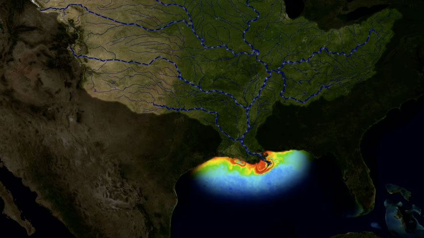
The early July 2016 prediction projected the area of low oxygen, commonly known as the ‘Dead Zone,’ to measure 6,824 square miles – an area the size of Connecticut and Rhode Island combined. The Zone is primarily the result of overuse of fertilizers from agriculture along the Mississippi River. After it rains, excess nitrogen from fertilizer application runs off into streams, creeks, lakes, and rivers, eventually making its way to the main stem of the Mississippi and ultimately, the Gulf of Mexico. Once there, algae take up the excess nutrient pollution—primarily nitrogen and phosphorus—and grow rapidly and then die, consuming oxygen in the water as it decays. Low levels of oxygen deplete fish populations and plant life that depend on oxygen for survival. Hypoxic conditions (defined as having dissolved oxygen concentrations of less than 2-3 ppm) cannot support freshwater or marine life and create dangerous toxins, like microcystin, which can contaminate drinking water. Read the press release regarding the 2016 Dead Zone measurement
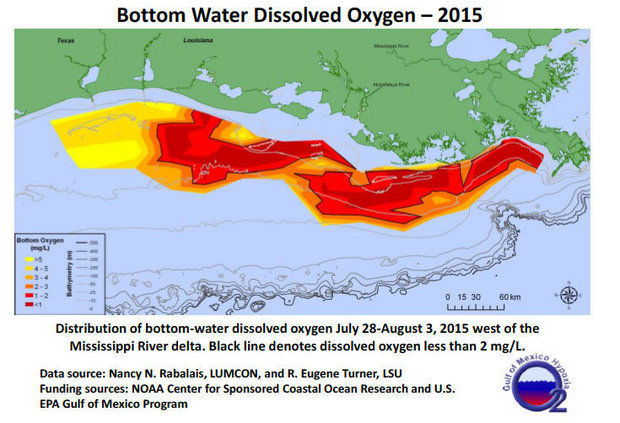
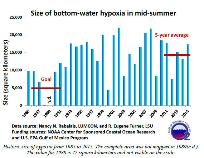
The Hypoxia Task Force is a group specifically created in 2001 to address the problem and is comprised of Mississippi River state representatives and federal agencies. In 2014 the Dead Zone measured 13,080 square kilometers (5,052 square miles)—about three times larger than the environmental target (5,000 square kilometers; 1,991 square miles) approved by a federal/state task force in 2001 and maintained by the same task force in 2008. The average size for the prior five years is 14,352 square kilometers (5,543 square miles).
NOAA and research teams have conducted the annual Dead Zone measurement every summer since 1985, but in a last minute decision, NOAA cancelled the annual 8-day trip due to mechanical issues on a new boat assigned to the project this year. The Mississippi River/Gulf of Mexico Nutrient Task Force was created to address the nutrient pollution problem with the original goal of reducing the Zone‘s size to 1,950 square miles by 2015. The measurement team is led by Louisiana University Marine Consortium scientist, Nancy Rabalais. In a Times-Picayune article covering the development, lead researcher, Rabalais noted, “Hypoxia in the Gulf of Mexico is a real threat to the ecosystem and all that rely on it. We have to continue to focus on nutrient reductions if we are to have healthy and sustainable fisheries. Unfortunately the long-range trend over the past 30 years continues to show little progress towards reducing the dead zone size to the 1,900 square miles that the task force has set.”
This year, the Dead Zone continues to be about three times larger than the goal that had originally been set for 2015. However, in February of 2015, the Task Force again extended the target date for shrinking the dead zone from its current average size of almost 6,000 square miles to about 2,000 square miles from 2015 to 2035. The target date refers to the central “Coastal Goal” of the Gulf Hypoxia Action Plan 2008 of “reducing the five-year running average areal extent of the Gulf of Mexico hypoxic zone to the original goal of less than 5,000 square kilometers (1,950 square miles).”
The driver creating this unprecedented environmental catastrophe affecting the ocean water off the coast of Louisiana is the nitrogen and phosphorus pollution from agricultural fertilizer runoff as well as the discharge from waste water treatment plants and industrial sources with nonexistent or weak limits on these pollutants. The excess nitrogen and phosphorus causes fish kills, death to livestock and pets, and damage to drinking water supplies.
Check out this video produced by Harvest Public Media for a synopsis of nutrient pollution and how it causes the the Dead Zone in the Gulf:
(Source: http://harvestpublicmedia.org)
MCE and the other members of the Mississippi River Collaborative (MRC) have advocated for numeric nutrient standards on basin states’ waters to restore the water quality in the Gulf and throughout the basin states. The Mississippi River Collaborative is a partnership of environmental organizations and legal centers from states bordering the Mississippi River as well as regional and national groups working on issues affecting the Mississippi River and its tributaries. “Currently we are seeing the impacts of nitrogen and phosphorus pollution, not only off the Louisiana coast, but throughout the country,” said Matt Rota, Senior Policy Director of the Gulf Restoration Network, member organization and member organization of MRC.
Despite voluntary initiatives to address the Dead Zone encouraged by the EPA and several state regulatory agencies, nitrogen and phosphorus pollution continues to be a major problem. This lack of regulation forced members of the Mississippi River Collaborative to petition EPA for action in 2008 and ultimately file suit against EPA in 2012. Specifically, this lawsuit was filed due to EPA’s refusal to set numeric standards for nitrogen and phosphorus pollution or ensure that states did so themselves in a timely manner. The lawsuit remains in litigation.