By Ed Smith
Originally posted on: 07/14/2017
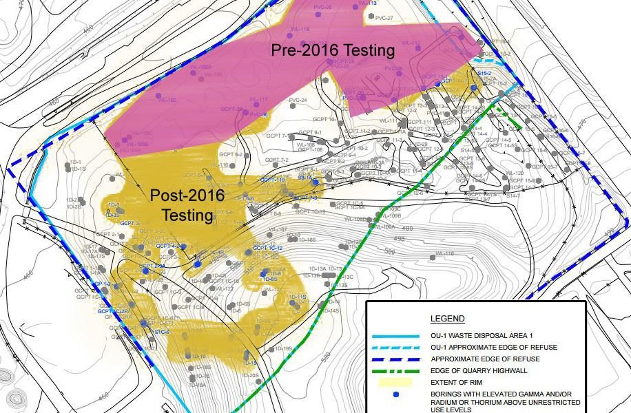
The Environmental Protection Agency (EPA) says it will release a proposed decision regarding radioactive removal in the very near future. MCE contends testing remains inadequate to reach a decision. The testing released in March 2016 revealed that radioactively impacted material (RIM) extends into the North Quarry of the Bridgeton Landfill. Whether the RIM extends beyond this point is unknown. The EPA has so far refused to test the estimated 600 feet between the known areas of radioactive contamination and the ongoing smoldering fire. The only way to be sure there is no radioactivity beyond the currently identified areas is to perform grid sampling throughout the landfill complex, which has never been done.
The West Lake Landfill started receiving garbage and industrial waste before state and federal landfill regulations were created, including the unauthorized dumping of radioactive material at the site in 1973. Since the EPA assumed jurisdiction in 1990, the agency has never required a complex-wide grid test to determine the extent of the radioactive contamination. Rather, the EPA has based its investigation for RIM on what is known as the “step-out” method. The step-out method means that testing begins at a point of known contamination and continues by literally taking a “step-out” from the contamination until the testing comes back negative. Most of the radioactivity is below the surface, so the only way to find out if areas of the landfill are contaminated with radioactivity is to perform a subsurface test.
The step-out subsurface testing failed to identify the extent of radioactive contamination at the landfill during two decades of EPA jurisdiction. It failed because the radioactive material dumped at the landfill was moved around and put in different areas before most of it was buried, or simply put, the contamination is not contiguous. The radioactive dumping predated regulations and occurred 17 years before the EPA was put in charge of the site. The radioactive contamination in the North Quarry may have never been found if not for the smoldering fire and testing for a proposed physical barrier, the plans for which have not yet been revealed.
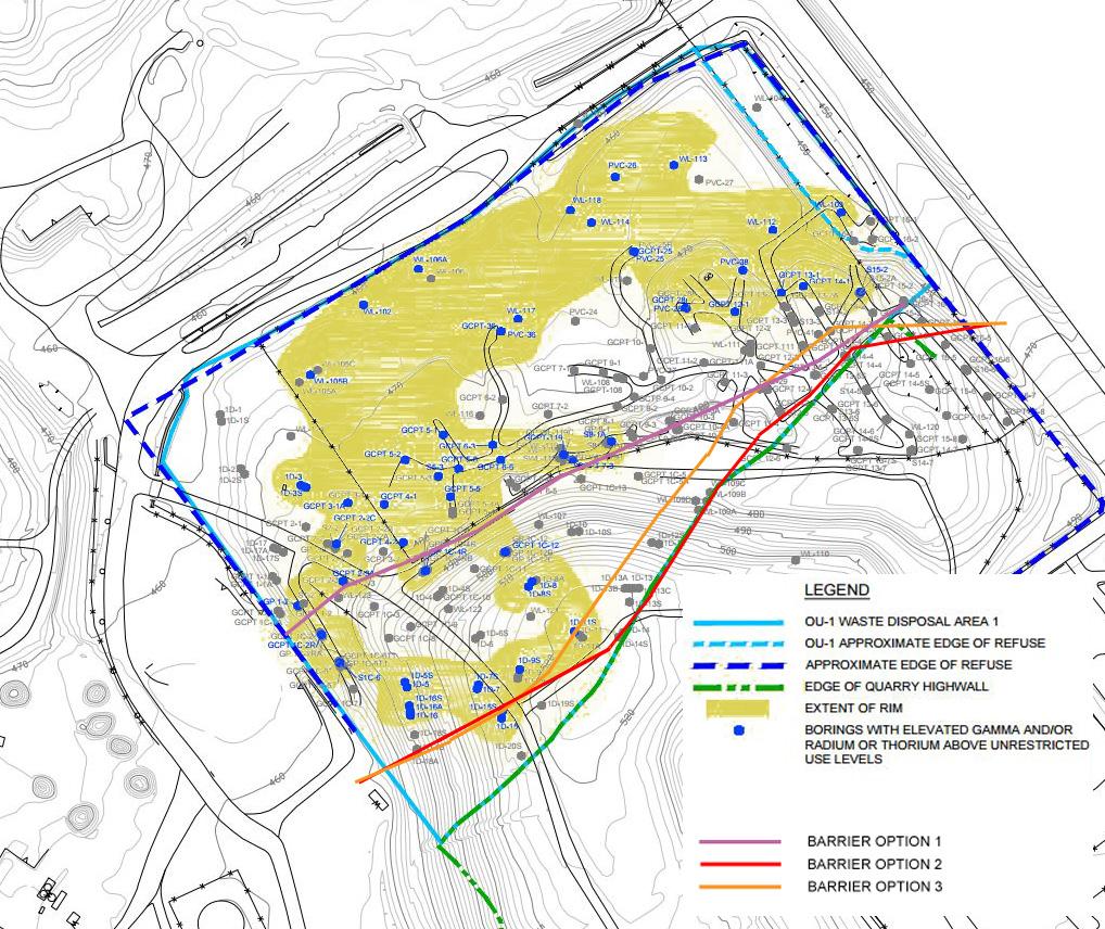
In 2013, Republic Services, the current owner of the West Lake Landfill, announced its intention to build a physical barrier between the radioactivity and the subsurface smoldering fire in the South Quarry of the Bridgeton Landfill. In August of 2014, the Army Corps of Engineers released three options for physical barriers as shown in the image below.
All three of the proposed physical barrier plans would have separated the known areas of radioactive material from the smoldering fire based on data in 2014. The EPA thankfully required potential barrier locations to be tested as a grid before digging could begin. It turns out the grid sampling for the barrier led to the EPA finding previously unidentified areas of radioactive contamination. The newly discovered radioactivity was likely there dating back to when the material was dumped, but it had not been discovered in the studies performed at the landfill from 1990 through 2014 because the area had not been tested.
If you observe the map below, which overlays the three barrier options over the most recent testing, you will notice that none of these three options would have effectively divided all of the radioactivity from the subsurface smoldering fire. It is clear from this map that extensive grid testing must conducted before the location of a physical barrier can be chosen or a final proposed remedy be recommended to the public.
The EPA has a responsibility to the community to make decisions using the best information available, but that cannot happen without a grid test of the entire landfill for radioactivity, especially in the 600 feet that separates the known areas of radioactivity from the smoldering fire. MCE ultimately supports the removal of the radioactive material from the landfill, which the EPA’s own National Remedy Review Board said can be done safely using available technology.
MCE’s Goals & Take Action
- Buyout for families living closest to the smoldering and radioactive West Lake Landfill Superfund site in St. Louis County. Read more.
- Removal of the radioactive material from the unlined landfill located in the Missouri River floodplain. Read more.
- Transfer jurisdiction of the radioactive wastes to the U.S. Army Corp of Engineers, specifically the St. Louis District of the Formerly Utilized Sites Remedial Action Program. Read more and take action.